


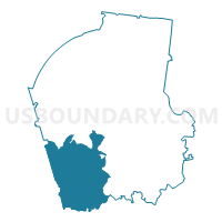
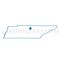
03 New Middleton Voting District, Smith County, Tennessee
About
Outline

Summary
| Unique Area Identifier | 669768 |
| Name | 03 New Middleton Voting District |
| County | Smith County |
| State | Tennessee |
| Area (square miles) | 46.19 |
| Land Area (square miles) | 46.19 |
| Water Area (square miles) | 0.00 |
| % of Land Area | 100.00 |
| % of Water Area | 0.00 |
| Latitude of the Internal Point | 36.14813320 |
| Longtitude of the Internal Point | -86.02673010 |
Maps

Graphs
Select a template below for downloading or customizing gragh for 03 New Middleton Voting District, Smith County, Tennessee


Neighbors
Neighoring Voting District (by Name) Neighboring Voting District on the Map
- 04 Rock City Voting District, Smith County, TN
- 05 Gordonsville Voting District, Smith County, TN
- 07 South Carthage Voting District, Smith County, TN
- 09 Commerce Cumberland Pres. Church Voting District, Wilson County, TN
- 09 Watertown Community Center Voting District, Wilson County, TN
- 1-1 Alexandria Voting District, DeKalb County, TN
- 1-2 Temperence Hall Voting District, DeKalb County, TN
- 15 Tuckers Cross Roads School Voting District, Wilson County, TN
Top 10 Neighboring County Subdivision (by Population) Neighboring County Subdivision on the Map
- District 15, Wilson County, TN (4,086)
- District 9, Wilson County, TN (3,876)
- District 3, Smith County, TN (2,667)
- District 4, Smith County, TN (2,534)
- District 1, DeKalb County, TN (2,517)
- District 5, Smith County, TN (2,494)
- District 7, Smith County, TN (2,318)
Top 10 Neighboring Place (by Population) Neighboring Place on the Map
Top 10 Neighboring Unified School District (by Population) Neighboring Unified School District on the Map
- Wilson County School District, TN (84,298)
- Smith County School District, TN (19,166)
- DeKalb County School District, TN (18,723)
Top 10 Neighboring State Legislative District Lower Chamber (by Population) Neighboring State Legislative District Lower Chamber on the Map
Top 10 Neighboring State Legislative District Upper Chamber (by Population) Neighboring State Legislative District Upper Chamber on the Map
Top 10 Neighboring 111th Congressional District (by Population) Neighboring 111th Congressional District on the Map
Top 10 Neighboring Census Tract (by Population) Neighboring Census Tract on the Map
- Census Tract 301.02, Wilson County, TN (6,640)
- Census Tract 310, Wilson County, TN (5,662)
- Census Tract 9752, Smith County, TN (5,634)
- Census Tract 9203, DeKalb County, TN (5,447)
- Census Tract 9754, Smith County, TN (4,463)
Top 10 Neighboring 5-Digit ZIP Code Tabulation Area (by Population) Neighboring 5-Digit ZIP Code Tabulation Area on the Map
- 37090, TN (12,922)
- 37030, TN (6,982)
- 37184, TN (5,844)
- 38563, TN (2,330)
- 37012, TN (2,292)
- 38547, TN (1,975)
- 38567, TN (784)